Invitation by Congress Director
"From human history to the future with spatial information"
Dear colleagues and friends, I would like to invite you to Prague and that is why I want to tell you something – about the city, us and our world.
Human history is (up to now) an endless development of relations between people and nature, between people and their ability to find something to eat and drink, find a place to sleep, and among people themselves. Other activities could have been developed after satisfying these necessities. However, knowledge, the art of drawing and the need to find a certain place ushered in the first – very simple – maps. Looking back, we do not know who had the first idea to create a “model” of a piece of the Earth. It is not important. There were many others who continued and created new drawings used as maps. They built an important foundation which we have been using in our spatial science – photogrammetry, remote sensing and GIS. We should recognize that these well-known and not so well-known people enabled us to use and continue in developing Ph&RS&GIS.
Living in the 3rd Millennium, we can profit from the achievements of millions of people from all over the world. Africa, Asia, Europe, America and Australia have their own advances in natural and technical sciences, literature, arts and music. We are using Greek names of illnesses, Latin names of human anatomy, Arabic digits, and Chinese medicine. We are still discovering the secrets of our Egyptian heritage, facing a similar subject of research in the Mayan pyramids. We do not know who created the first boomerang in Australia or geoglyphs in the Nazca region. Who created the first sugar cube and when? A director in a sugar beet factory invented the sugar cube after his wife injured herself trying to extract a small piece of sugar from a sugar loaf. The man lived in Dačice (in Moravia one half of the Czech Republic) and created the first cube in 1841.
We use paper and pencil, bicycle and car, silk and fleece, radio and radar, perfume and pearls, telephone and television, SMS language and GPS navigation, spectacles and scanners … We do not admire these things, as they have become a natural part of our life.
These are the results of artists that we admire in most cases. Prague can offer you many examples of these from the 2nd millennium being not only a real jewel of the baroque style with many diamonds, but also a textbook with tens of examples throughout many artistic styles.
I would like to invite all Ph&RS&GIS scientists and specialists in a great multitude to Prague to see that people living in previous centuries helped us to be able to reach the present state of art we have reached in all aspects of our lives.
Romanesque vaults showed a human ability to build a hemispheric roof. Gothic style raised roof heights; Renaissance style interconnected again human life and nature. Baroque is the period of the printing press invention - for maps too, the probability theory was defined by Blaise Pascal who probably knew the music of Johann Sebastian Bach, his contemporary.
Time ran on and the photograph was invented by Louis-Jacques-Mandé Daguerre during Romanticism of the 19th century, a period of Alexandre Dumas, Edgar Alan Poe, George Gordon Byron, Alexander Sergeevitch Pushkin, Francesco Goya, Hector Berlioz, Franz Schubert, Felix Mendelssohn-Bartholdy, Fryderic Chopin, Bedřich Smetana and many others.
Art Nouveau brought along the years of balloon photographs and of Honoré de Balzac, Alphonse Mucha, Antonio Gaudí y Cornet, Adolf Loos, Gustav Klimt. The first years of the 20th century when Julius Neubronne used his pigeon for photographs from the air, and the beginning of cubism, a style created by Pablo Picasso and Georges Braque. Prague is a nest of the highest number of cubist style buildings in the world. It was during the First World War when both sides used aerial photographs many times.
The 20th century traces are in functionalism with Le Corbusier, the new town Brasília, aviation, astronautics, jazz and computers. The end of the 20th century smoothed the differences between spatial resolution of satellite and aerial data, mobile telephones are now used by all generations, while millions of people are still starving.
In the first decade of the 3rd Millennium, while the Brazilian rain forests continue to shrink, many people working in Ph&RS&GIS, are actually able to show evidence of the loss of this precious biosphere.
Europe uses the Euro, less and less people are able to make a fire, or walk more steps than drive kilometers per day using the navigation in their smart phones and remote control for switching on whatever. Come and walk through Prague and other parts of my country, look around, realize the brilliant advances of our predecessors and try to continue to use our knowledge to move human progress while tasting Czech beer and Czech cuisine. Try to read Czech words forming one of the Slavonic languages; you should know that it is one of the most difficult languages in the world.
People will appreciate it if you say “ahoj” [ahoy] = hi.
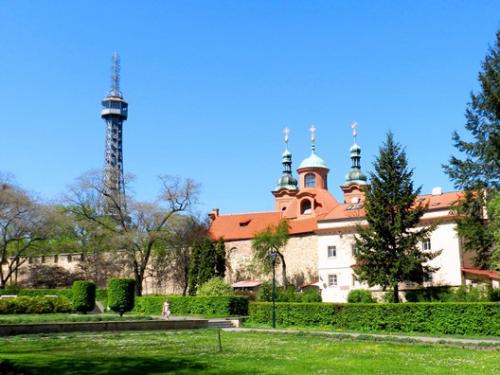
Dear colleagues, I would like to invite you to my country of birth and town, which I love very much. You can find all architectural styles mentioned above here, places for painting and music lovers or photographers. Prague has the oldest university in Central Europe, the longest continuous daily temperature measurement and one million and nearly three hundred thousand inhabitants.
The XXIIIrd ISPRS Congress is an excellent opportunity to see and confirm that it is worthwhile to organize a scientific meeting for photogrammetrists, remote sensing specialists and geoinformatists from all over the world in the Hundred-Spire City, Prague in 2016.
Come to Prague in the year of the one hundredth year anniversary of the first year of “summer time” in the Austro-Hungarian Empire, the battle of Verdun, and the publication of the theory of relativity by Albert Einstein.
Lena Halounová